


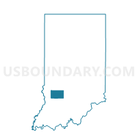
WASHINGTON 2, Greene County, Indiana
About
Outline

Summary
| Unique Area Identifier | 577349 |
| Name | WASHINGTON 2 |
| County | Greene County |
| State | Indiana |
| Area (square miles) | 27.65 |
| Land Area (square miles) | 27.42 |
| Water Area (square miles) | 0.23 |
| % of Land Area | 99.16 |
| % of Water Area | 0.84 |
| Latitude of the Internal Point | 38.95445440 |
| Longtitude of the Internal Point | -87.08229460 |
Maps


Graphs
Select a template below for downloading or customizing gragh for WASHINGTON 2, Greene County, Indiana


Neighbors
Neighoring Voting District (by Name) Neighboring Voting District on the Map
- CASS, Greene County, IN
- GRANT, Greene County, IN
- STAFFORD, Greene County, IN
- STOCKTON 01, Greene County, IN
- VIGO 01, Knox County, IN
- WASHINGTON 01, Greene County, IN
Top 10 Neighboring County Subdivision (by Population) Neighboring County Subdivision on the Map
- Stockton township, Greene County, IN (8,447)
- Vigo township, Knox County, IN (4,031)
- Washington township, Greene County, IN (1,186)
- Grant township, Greene County, IN (739)
- Stafford township, Greene County, IN (448)
- Cass township, Greene County, IN (358)
Top 10 Neighboring Place (by Population) Neighboring Place on the Map
Top 10 Neighboring Unified School District (by Population) Neighboring Unified School District on the Map
- North Knox School Corporation, IN (8,842)
- Linton-Stockton School Corporation, IN (8,447)
- White River Valley School District, IN (5,783)